This week we’re on an excursion across the Kensington and Chelsea border into new territory. I hope you’ll forgive this incursion into unfamiliar streets but when I came across these pictures, which came with a donation of papers, maps, photocopies and photographs. I was fascinated by them. The late 1950s is a time which looks both familiar and alien to me as history overlaps with my my own timespan.
The locations themselves were not immediately familiar but the London of post war dilapidation and demolition was recognizable. A few street signs were visible so I gradually placed them in that area to the north and east of my home Borough on the far side of the Harrow Road. These streets in the old Borough of Paddington seemed like an alternative version of North Kensington.
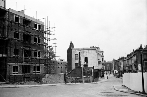
This view reminds me of a section of Portobello Road. The curve to the left as the road goes up the hill. But that side street is Lord Hills Road in W2 not W11. I tried looking on Google Maps at the view today but couldn’t see any of these buildings.
Behind the busy streets the process of demolition has begun. In this picture you see a first glimpse of a half byzantine half Gothic church which I saw in many of the pictures from different angles. I’m trying to avoid letting my imagination run away with me and put it into some kind of urban supernatural story.
In another kind of urban story, a kitchen sink drama or an angry young man a lone cyclist enters the construction zone where demolition has opened up a wide space.
Bottom left,the sign of the Willett company, builders and developers (their headquarters in Sloane Square at this date) on the edge of the site. A number 18 bus passes by along the Harrow Road going between Sudbury and the West End.
It’s there again in a wider view. I can’t quite orientate myself in this picture in relation to the rest of the city but those chimneys on the horizon should provide a clue to someone.
A last glimpse at one of the side streets from this area. The abandoned car, which we’ve seen in other posts ten or more years later, was already a feature.
And a final view of the church looking even more as if it was on the edge of a precipice about to fall to its destruction.Image may be NSFW. Clik here to view.
Postscript
I hope you haven’t minded visiting an area where I’m not much use as a guide. It’s an odd sensation for me feeling lost in an old photograph. That was part of the fascination. I know some of you aren’t limited by the same geographical boundaries as me so feel free to comment with your own identifications.
When I first looked at Bernard Selwwyn’s pictures of 1950s Paddington I had no idea I was working with someone who knew a great deal more about the area than me. So this week my colleague and friend Isabel Hernandez is guest blogging, about a neighbourhood she knows very well:
You may recall a post Dave wrote a little while back called Unfamiliar Streets: Paddington 1959…It so happens that when I had the opportunity to view the photographs within that blog I realised to my surprise that I was very familiar with these northern Paddington streets. Views of the Warwick Estate prior to its redevelopment beginning around 1959 and the early 1960s were images I had never seen before, and considering I spent my entire youth growing-up on the relatively new estate, it really was like entering a time capsule. Very few of the original buildings survive now, with the exception of St Mary Magdalene’s and the local Victorian schools which I will talk about later, and some of the bigger, grander houses around Blomfield Villas. There have been name changes too: some abolished, others given to rebuilt roads such as Clarenden, Woodchester and Brindley.
Below is an image of Bourne Terrace, previously Westbourne Terrace North. The photograph appears to have been taken from Torquay Street which backs on to the now Westbourne Green Sports complex, opened around 1976. The railway lies directly behind that with the Westway looming large alongside it. On the corner of Bourne Terrace you can see 264 Saws Ltd and various blocks which no longer exist. They look to be derelict and ready for demolition with people going about their daily lives as usual. Nobody in that scene seems to have noticed the camera.
Here’s another photograph showing Bourne Terrace, only this time one of the blocks has already been demolished. Already a new build has been erected on the left – the familiar flats of the current Warwick Estate. The spire of St Mary Magdalene’s is clearly visible in the background.
Below is the Harrow Road with Bourne Terrace to the right and what appear to be lines set up for trolley buses. They were certainly gone by the time I moved in. The 18 and 36 bus routes were diesel run, ironically less clean than the electric bus option. All these blocks are now gone: the billboards, the shops. My memories of this part of the Harrow Road are not dissimilar to what exists today. To the right is a high rise block, possibly Brinklow House. Further up on the left, past the block of flats, existed the Westminster Council Offices (now an academy) and below that, garages where I housed my first car. To the right there was a Londis, a video shop (the epitome of visual technology at the time) and George’s chip shop. Each business had a residing family that we all knew well. People tended to stick around in the same community for a long time.
Here’s another street which runs parallel to Bourne Terrace. This is Cirencester Street. To the right is the Roman Catholic chapel, Our Lady of Sorrows where I first had confession and had to wrack my 8 year old brain into confessing something inoffensive, like I really didn’t like my breakfast that morning, much to the priest’s amusement. Soon after, I did my First Holy Communion where my friends and I looked rather charming in our white dresses and suits. The chapel itself is quite beautiful inside.
Next to the chapel and above it – although not obvious – is my old primary school Our Lady of Dolours. The school was founded on this site in 1872 having previously been managed by priests of the church of St Mary of the Angels. It’s one of the few schools in London to still have a roof playground. At this point the school had yet to convert the front part opposite its façade into the front playground. I have many fond memories of the old place and I’ll never forget how small it looked when I returned many years later to visit. It must be true for all those who visit their old primary schools. We grow and mature and yet we’re not really sure when and how it all happened.
Here’s the chapel again with the camera facing Desborough Street. The blocks to the right face onto the Harrow Road looking rather shabby and derelict.
Below is a view of Our Lady of Dolours from a higher vantage point. Already the shabby, block opposite has gone and new flats are being built in the surrounding area. The high-rise block under construction is Wilmcote House, the first of six, high- rise blocks in the Warwick and Brindley Estates.
Here’s another high vantage point of view. Our Lady of Dolours and Our Lady of Sorrows sectioned off and Wilmcote House nearing its 20/21 storeys. I lived in Gaydon House, nearest to Royal Oak and possibly the last of the six blocks to be built. Great views over London if you lived on the uppermost floors.
Here’s Wilmcote House from the view point of St Mary Magdalene’s. To the far left is Edward Wilson C.E School. I assume named after the physician and naturalist who died on the ill-fated British Antarctic expedition lead by Captain Robert Scott in 1912. Edward Wilson practiced as a doctor in Paddington in his earlier years.
Edward Wilson School seen from the back possibly from Cirencester Street. The skyline is a little different now with Gaydon House directly opposite the front of the school and the Westway marking a path through the lower horizon towards Edgware Road and Marylebone Road.
St Mary Magdalene’s in the distance with the endless row of houses leading up to it. This gives you an idea as to how little space there was. It was designed by the architect George Edmund Street and it is often described as a ‘long, tall narrow design’ simply because the layout of the former streets gave little room for width. Now, of course, there is a spacious green behind the church with the Grand Union Canal running parallel to it. As children after school lunch, usually a hideous concoction of hard boiled potatoes, spam and simpering vegetables that would probably make Jamie Oliver’s toes curl, we would be taken by dinner ladies to the green to play. We would often dare each other to go up to the church wall, put our hand on it and count to ten – seems perfectly harmless – except we just knew it had to be haunted. To our point of view a gothic behemoth such as that, towering over our small frames was good enough reason to allow for our vivid imaginations to concoct some fantastical cowl covered floating monks to be living there in all their frightening silence. I know now that this is quite impossible. St Mary Magdalene’s was only completed around 1878. No cowled monks in the area at the time as far as I know.
Here is the church again a little closer, from the other side of the canal. I have always admired its red brick walls and unassuming character. It’s not surprising it is often used as a film location. A church ‘completed by degrees’ in the middle of a crowded residential area. Now it stands as the centre piece of the Warwick Estate. If you want more details about the church, Pevsner’s London 3: North West is an interesting read.
The Warwick Crescent development underway; note the leaning lamp-post in stark contrast to the massive crane beyond the corrugated barriers. Out with the old in with the new. It seems a shame that these could not have been restored – as far as street furniture goes these were rather attractive.
The new blocks of flats were going up as soon as the rubble from the old houses was cleared. Presumably, rather than demolish everything in one fell swoop and displacing many residents, it made sense to demolish sections and rebuild, that way you could re-house people in increments and not displace them for too long.
I will conclude my post with this image. Here, the old and the new seem to co-exist in an absurd time warp: old houses new flats. Note the lampposts again! Here we see (what I assume) are residents passing through what appears to be Lord Hill’s Road. It now connects Senior Street with Delamare Terrace. I imagine a mother with her shopping trolley; gentlemen in suits, perhaps finishing work for the day; somebody on a motorbike and a chap looking at the camera on the other side of the road taking an interest in what our photographer is doing. It’s difficult to see unless you expand the image. They all seem to be taking the huge redevelopment in their stride quite literally. I wonder what they thought of it all.
I came to the Warwick Estate as a child in the early 1970s and my first impressions are still relatively clear in my memory: tall high-rise blocks, lots of green spaces to play in, a canal full of sticklebacks and the ever stoic St Mary Magdalene’s at the centre of all the residential flats. Being a new girl on the block what I experienced was the London County Council’s post war answer to social housing. I never realised – now looking back at maps and photographs – just how densely populated the area was with narrow streets. A true Victorian relic. I had never seen what the area looked like before my tenure there so to have looked at these images and given the opportunity to talk about them was a real treat. Some of you reading this may be familiar with these Paddington streets and may even remember how it was before the cranes arrived on the scene. There is so much I’m still learning about my old haunt; for example, I had no idea that the painter, Lucien Freud had a studio in Delamare Terrace and later in Clarenden Crescent. Did you? History always has a way of inviting you to delve further. I would never say I know everything there is to know about my old address because I clearly don’t but I hope to have piqued your interest just a little and that you have enjoyed looking at these photographs as much as I have.
This week features the return of guest blogger Isabel Hernandez who has subjected our recently acquired collection of pictures of the construction of the Westway to close scrutiny.
Below are a few images taken from a set of photographs I have been working on showing the construction of the Westway from the Paddington perspective. Quite a few of the photographs were taken from the roof of my old home (Gaydon House) which certainly was of personal interest as I looked through them.
As a child growing up with the Westway in close proximity perhaps I should feel some sort of affinity for it. I certainly never thought it attractive. It was just always there: a city structure, part of the landscape…the truth is, I never gave it much thought. Such edifices are often described as eyesores for the most part – much like electricity pylons are along country fields – it was to me a modernism that (literally) passed me by. The Westway was a fixture I grew up with. I knew nothing of its history or the controversy surrounding its construction, let alone the disruption and the displacement it caused. It was simply concrete: imposing and strangely pragmatic. It was many years before I really got to know the story behind one of London’s more contentious projects.
The image below shows the south of the Harrow Road, opposite Lord Hill’s Bridge being filled around 1966. The middle building directly behind the corrugated iron is Gaydon House with the Victorian school, Edward Wilson, next to it. The difference in size is evident. The school is not a small building and yet it is dwarfed by the 21 storey block. Many of the aerial views for the area during the project were taken from the roof of this high-rise block.
In some ways I am a child of the concrete era, when Brutalist architecture, as it was known, became the progressive force in the construction business. Laing was one of seven major construction companies responsible for much of the redevelopment in the Great Britain of the sixties and seventies. It was in their interest to champion “the strength and simplicity of concrete” (White Heat: A History of Britain in the Swinging Sixties 1964-1970 ~ Sandbrook). It was considered the answer to the ailing, defunct, overcrowded Victorian slums that were being cleared as the redevelopment boom took hold in the 1950’s and 1960’s. Concrete was the new emperor, running roughshod (as perceived by many) over history and traditional Britain like a lava flow. But I was oblivious to all this. By the time most of this had happened I was already a part of this infamous megastructure: I resided in a tower block on a housing estate with a massive motorway next door – you can’t get more concrete than that!
In this photograph we see the beginnings of an area in transformation. A large section of what will become a part of the Warwick Estate is being prepared to hold the materials and moulds for the soon to be motorway that will run parallel to the Great Western Railway. The white arches (top left corner) are part of Paddington Station with the Westbourne Bridge just before it.
This view (below) would have been a familiar one from my balcony, except it predates me by several years and the Westway has yet to appear. I suspect some form of long lens was used here to photograph this section of the Harrow Road with Lord Hill’s Bridge just off it. You can also see Royal Oak Station serving the Hammersmith & City line on the left of the bridge. Today it remains largely unchanged with the staircase leading down on to the platforms. Now, with the Westway present, you cannot really see it this clearly anymore from the lower floors of Gaydon House.
Three months later and we see the beginnings of a subway. This served pedestrians who wished to cross the busy Harrow Road over to Lord Hill’s Bridge that leads on towards Porchester Road and Queensway. In subsequent years most of us residents would still risk the busy road rather than venture below deck, so to speak. But to be fair it was never threatening or particularly dangerous during my time living in the area. Occasionally the compulsory graffiti would decorate the dirty, dull walls, but overall it was thankfully devoid of harder criminal activity. It is only in recent years that it was decided to seal off the subway for safety reasons. Not so much because of its insalubrious elements, but more to do with the fact that people preferred the more direct route on ground level, risking life and limb.
Below, looking east towards Paddington. This is the route of the Westway. The Great Western Railway and the Harrow Road follow on either side of it. In the distance you can just about make out the spire of, what I think was, Holy Trinity Church on Bishops Bridge. The church itself was demolished around 1983/84 but the spire was taken down earlier C. 1972. There are now some unremarkable flats built in its stead called (to rub salt in the wound) Trinity Court.
Here you see Bourne Terrace in June 1967 (bottom right) leading on to the Harrow Road. Anyone who has read my previous blog called Familiar Street: A Paddington Estate might recognise some of the streets. Many old streets were abolished and new ones created. This aerial view is taken from Gaydon House (my old residence) pre-Westway with construction underway all around the Warwick and Brindley (soon to be) Estates. The Westway has yet to parallel the rail track of the Great Western that will encroach from the west. Up ahead is Westbourne Park Road which you can reach over a pedestrian bridge walkway. It’s the first bridge you see by the wasteland. An area that is now the Westbourne Green sports complex. North Kensington is in the distance. If you look closely you might be able to make out the tower of St Charles’ Hospital (extreme top right).
At first this picture confused me. I thought I was looking at the foundations of what would become part of the Westway. But on further study I realised this was actually the precast yard for the motorway (where large sections of concrete would be moulded) as well as being a storage area for all the heavy materials and machinery that would be used for this section of it.
Below, Brinklow House in construction and to think that double-glazing was never even considered with the Westway looming next door. I can remember listening to the motorway traffic whizzing by. Eventually it became background noise along with the trains, the planes and the automobiles. The sirens too get a special mention. When the towers were eventually refurbished around 2004/5 double-glazing was put in. I had left by then.
March 1968 and here we can see the beginnings of the motorway rising up off the ground. If you want perspective take a look at how small the cars are, driving along the Harrow Road.
The Westway encroaching from the west. By April 1968 the Paddington section was rising fast.A diesel train heads towards Paddington Station and behind that, blocks of flats along Westbourne Park Villas adds to the strangely linear synchronicity of the whole image.
The Westway is taking shape as the traffic below continues to ebb and flow as normal. The chaps on the motorway, probably inspecting sections of it, look like they’re exploring a playground. It was not unusual to find workers of the period (depending on their assignments) not wearing the required hard hats or safety gear compulsory today. Below left you can also see a number 18 routemaster heading west towards Harlesden, possibly Wembley. It still continues on a similar route to this day.
See the caption on the picture below. What is an epox pipe you may ask yourselves? The truth is I have no idea. But I think it has something to do with a strong, protective coating that can be used on piping or bars in concrete to reinforce it. All those dials and conducting cables make me think of physics lessons. It was a science that flummoxed me. As do epox pipes.
Here is my own blurry photograph of the Westway taken in the early 1990’s during the autumnal season. It was taken with one of those incredibly daft 20th century inventions – the throw-away camera. I snapped this from my balcony, which incidentally, boasted one of the best views of London. The small park below – once a slum, then a wasteland converted into a temporary building site – gives this particular corner of Paddington a lighter, less congested feel, hinting back to its former rural history and remarkably, the Westway, despite its initial ugliness and awful connotations, actually doesn’t look so out of place here. Not anymore. Something natural to balance out the progressive, intrusive advance of technology seems to be the secret here. Concrete used unwisely is a monster. But, temper it with an intelligent creative flair and you could be looking at a masterpiece. Love it or hate it, the Westway is here to stay.
This week we have the long awaited return of my occasional co-blogger Isabel Hernandez who grew up in the area sometimes called North Paddington and has many memories of it as it changed in the years around the building of the Westway. Like myself she has been looking closely at the photographs of Bernard Selwyn.
The city skyline changes over decades much as mountains change shape over centuries. Our small local areas, places we call home, or used to call home, places we are familiar with, are no different. These urban cityscapes seem to undergo a makeover every fifty years or so. From the overcrowded terraces of the Victorian period to the later concrete brutalism of the 1960’s, we are now witnessing the era of glass and mirrors built in angular shapes in what is now contemporary modern architecture.
Still, the shadows of the past remain in photographs and to continue with my study of the Westway (Paddington-side) I thought I would share with you a few more images of this corner of London before the infamous Westway motorway was built.
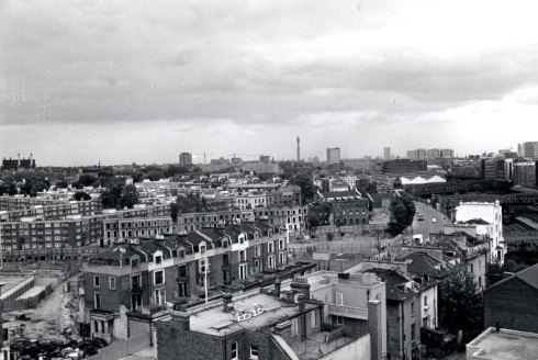
Below is a panoramic view of North Paddington bordered by North Kensington at the top. You can see the Kensal Gas Works and the St Charles’ Hospital tower, formerly the Marylebone Infirmary. [Click on the image to see a bigger view]
The Great Western Railway to the left cuts unimpeded through the built-up area.
Below,a closer view. In the background you can see Ladbroke Grove bridge more clearly, connecting North Kensington to Paddington. If you look closely there is also a footbridge on the left that appears to have a tree growing out of it. Obviously it isn’t, but from this angle the bridge resembles a horizontal chute. It wasn’t a very appealing crossing, but it was a shortcut through to Westbourne Park and North Kensington. I made use of it many times, sometimes late at night, probably not a very wise thing to do with hindsight, but it saved time. The dilapidated Victorian houses, a stark contrast to their taunting new neighbours, await the bulldozer. Nowhere was there a more densely packed neighbourhood than in this part of Paddington.
The houses come down and a temporary wasteland is created, with the exception of these houses in the foreground. They do seem a little grander than the terraces behind them and I wonder why they are still standing at this point when their neighbours have been demolished
The strange case of the solitary houses. I suspect they were slightly more upmarket than the usual fare in the area. There is also the interesting feature of the residents coming and going as has always been their routine perhaps; shopping or simply getting from one place to another. The lady (left of the house) probably had no idea she was being included in a photographic survey.
If you like trains, then the Great Western Railway before you would have been a spotter’s delight. Below is possibly Alfred Road or Torquay Street in the pre-redevelopment period. There is a builder, or certainly a very brave man,who appears to be intently prodding the side of a roof with a stick. By contrast an elderly gentleman with a walking stick is passing by, perhaps studying the changes in his area. Although there is a lot of pixilation when studying photographs at close range, when they are enlarged there is still enough to intrigue us.
The juxtaposition of the concrete towers to the dilapidated, slum terraces is a striking image – like two Lego blocks strategically placed inside of a crowded moat. Although you cannot see it, running parallel to the two tower blocks is the Grand Union Canal.
Below is a composite image of three photos showing the lower end of the Harrow Road. None of the shops seen here along the length of the long street now exist. Many have been replaced by the various convenience stores and take-away outlets you see today. On the corner of Bourne Terrace the Stowe Club was opened, now a doctor’s surgery and offices I believe. Many residents within Paddington and North Kensington did a lot of their shopping along the Harrow Road.
Westbourne Grove, by contrast (to digress a little), was more the Bond Street of the area with William Whiteley identifying the road as having future potential once the underground railway opened in 1863 and many more transport routes being opened up. He opened a small drapery in the area, tentatively doing what is essentially market research and gaining experience before expanding to what later became the department store, Whiteley’s of Queensway, attracting and catering for the wealthier clientele residing around Bayswater and Hyde Park.
Here is another image of the same area, magnified a little to give us more detail. If you look closely you will see the ‘Tardis’, a police box, no doubt placed there to keep an eye on things whilst the area was undergoing its concrete revolution. A billboard to the left advertising glue is almost comical given the toy-like remodelling we see from this perspective
In the picture below, the Post Office Tower, the highest building in London at the time, can be seen in the distance. It is almost impossible at this point to imagine the Westway being a part of this landscape. The Harrow Road here is clearly seen under an open sky. Within a few short years all of the buildings on either side of the Harrow Road in this image were demolished, and the Harrow Road itself partially covered by the huge motorway above it. Engineering ingenuity in the name of progress or engineering folly – a question that is still debated today.
I had to include this one as it’s my old address – Gaydon House. I lived there for about 26 years. That is a long time to be anywhere. The rather forlorn, gothic-looking tree in the foreground appears in quite a few of the photographs before it was unceremoniously cut down to make way for more flats and other younger saplings ready for the next generation. All remnants of what came before, almost vanished within a ten year span.
Below is Westbourne Park Villas. It runs parallel to the Great Western railway on the other side of the tracks. The spire of St Matthew’s Church can just be seen to the right of the image and in the middle you can just about make out the dome of Whiteley’s. A little behind that is the dome of the Royal Albert Hall. On the left, along Bishops Bridge Road, are a series of buildings that make up what was known as The Colonnades up until recently, before Waitrose took over. Further back, (I had to really expand this image), you can make out the four chimneys of Battersea Power Station. After being derelict for many years, and a few investors later, it is now undergoing a major redevelopment: the usual combination of luxury flats and shopping outlets so typical of London now.
Here’s another view of Westbourne Park on the other side of the tracks, looking further west towards Notting Hill and Kensington – an interesting mixture of modern flats and late 19th century villas.
And finally, a colour image of the Harrow Road most likely photographed by Selwyn from Wilmcote House, the first tower block to be built of the six now in existence. Two buses (probably the number 18) can be seen making their way north. Interestingly there existed along the Harrow Road a 2 ½ mile track from Amberley Road to Harlesden around 1888 for trams. These were replaced around 1936 by trolleybuses and later still (1961-2) by motorbuses such as the ones you see in this image.
As always Selwyn’s wonderful collection of photographs fails to disappoint. Dave and I have posted a number of them now on the blog knowing that you will probably appreciate them as much as we do. Or at least we hope you do. The posts I have written thus far about this part of Paddington are obviously a trip into a past that pre-dates my tenancy there, but in my view, still feels so very familiar and nostalgic. Now, not having lived in the area for a few years, I feel more like an outsider looking in with an abstract knowledge of a community I was once a part of. What I realise when I look at historical photographs, is just how temporary everything is, and how changeable. The only forever in these instances are images such as these frozen in time. Perhaps this is why we always find them so appealing. A record of a slither of time that we witness much as a fictional Time Lord in a Tardis would. Except we do it without having to travel very far.
Postscript
Thanks to Isabel for another fascinating post. I particularly like the panoramas she has created, something Selwyn himself used to do using the medium of sellotape. Once again, if anyone knows an easy way of adding an author in WordPress I’d be grateful.
I will spend my week off working on some new posts in an unhurried languid sort of way and return next week with some of the usual stuff.
This week’s post is written by my colleague and friend Isabel Hernandez. It’s a day later than usual, but that’s my fault, not hers, as I was off for a few days after a minor medical procedure.
It has been a little while since my last contribution to The Library Time Machine, and I am long overdue on this blog that, really, should have been written several months ago. It was during this time that I was fortunate to have met local photographer, Peter Dixon, during an exhibition that was held in the Central Library and organised by the Gloucester Court Reminiscence Group. On display were some fantastic photographs he took in the 1950’s and 1960’s, mainly of the North Kensington and Paddington areas, which had never been seen before. So, it’s with great pleasure that I am able to share with you some photographs that Peter Dixon was kind enough to give us as part of the Local Studies collection.
Later on in the postscript I will add a link to the website that shows more of Peter’s work and also how the project came about. I think you will find it of great interest, and is well worth a visit.
Above is one of my favourite images of the Harrow Road showing the New Red Lion pub. It has that magnificent lion on the top which I imagine must have been red. I’m probably stating the obvious, but it was before my time and I never saw it before the pub was demolished. To the right is a billboard advertising lager, just in case you fancied something other than your usual brew.
The New Red Lion was one of many pubs in the area, but it is listed in the directories (at least) since 1902. It survived many decades and probably served a good number of those employed by the Great Western Railway. As well as the station there were several wharves, Goods yards, and the Grand Junction Canal. Enough to keep the pub busy with workers enjoying some respite.
If alcohol wasn’t to your taste, there might have been the possibility of some milk. To the right of the Westbourne Bridge, practically next door, there used to exist a number of cattle pens, evidently serving a dairy that must have supplied the local area.
Beyond the Westbourne Bridge was Bishop’s Bridge Road. Some of you may remember the Bridge Café. But here I digress.
Above Is the junction between Lord Hill’s Road and possibly Westbourne Park Crescent. Familiar territory for those of you following the Paddington blog posts. What’s great about the following images is how Peter captured the local people. He was able to snap images of people going about their business or posing. Children, particularly, were often seen playing on the streets. In those days we didn’t have the technology or the means to amuse ourselves with the current plethora of indoor entertainment we have now. We spent more time outdoors, making up our own games.
A young lad on his bicycle possibly looking at the strange, if not cheeky, graffiti on the pillar of the house in front of him. Most of the houses in the area at this point were condemned for demolition to make way for the new Warwick Estate.
A bonfire burning fiercely to the left of the image. The gentleman in the foreground could be one of the workers in the area burning flammable items (wood perhaps) that might have resulted from the obvious destruction of the old houses once the bulldozers moved in. Safety helmets and formal attire were not compulsory at the time so it’s difficult to say if this was a construction worker, or a local resident. In the background you can just make out the eerie shadows of the new blocks that were going up almost as quickly as the terraces were being demolished. The past and the future, as I have probably mentioned in previous posts, was very marked during this period of redevelopment. It’s not unlike those glass behemoths being built all over London today giving everything a futuristic flavour.
St Mary Magdalene to the right, next to what I think was Woodchester Street. All the existing streets at the time were later demolished, rerouted or renamed. In the background is a tobacconist with the title: The Boar’s Head Tobacco, and a grocery shop: I &S Jones, advertising what looks like, Benedict peas. It would appear the premises were already vacant and no longer serving the local community at this point. There is a large ‘Sold’ sign between the two stores.
Two chaps smiling at the camera. Peter did say that people were generally very friendly and obliging when asked if they could have their photo taken. It was considered something of a novelty.
And here’s another wonderful image of some children being candidly themselves sitting outside a convenience store. Confectionery of any kind was always considered a real treat and the young lad in the middle is clearly enjoying a lollipop as he poses for the camera.
Two boys crossing the footbridge that links Formosa Street with Lord Hill’s Road, separated by the canal.
The footbridge no longer exists as you see it here. It was originally built by the canal company, taken over by the Metropolitan Board of works, and later conveyed to the vestries. I used to call it the dodgy bridge. It always seemed so destitute and neglected. Every time it was newly painted, it wasn’t long before the graffiti would leave its mark and time would strip away its freshness.
I used this footbridge frequently whenever I walked towards, Warwick Avenue, Maida Vale or to the library in Sutherland Avenue. It was replaced in the 1980’s, perhaps early 1990’s (if I remember correctly) by a far nicer, more open footbridge that has a better view of the canal and the surrounding area. The Paddington Stop pub as I remember it (now a gastro pub called The Waterway) was on the corner, and all the wharves that existed opposite Clarendon Street over the canal were all eventually pulled down and the area became residential with the Amberley Estate built as part of the redevelopment of the area.
The bridge with the canal and Delamere Terrace in view. The terraces you see were subsequently demolished and replaced by the flats you still see today as part of the Warwick Estate. The lady in the image appears to have, what looks like, a wash bag with her. Not an uncommon sight at the time. The luxury of having a washing machine is a relatively modern concept. I distinctly remember in my early years my mum taking our laundry, with us in tow, to the local launderette on the Harrow Road. It was next door to the off-licence, just before Cirencester Street. The interminable waiting for the washing cycle to end rendered me bored most of the time, so I would often have a library book with me to ease my impatience.
The same side of the bridge. Only here we see Blomfield Road where the difference in housing was evident. The villas that still exist along this side of the canal were a marked contrast to the terraces opposite. We always remarked on this distinction. ‘Posh people’ lived here! Perhaps these gentlemen were moving in?
A fantastic photograph taken from Delamere Terrace showing the wall that divided the street from the canal. The footbridge was flanked by a house, and at the foot of the stairs you can see a slightly leaning telephone box that seems, in my fanciful mind, like it doesn’t want to be there. The leaning phone box of Paddington was not there when I moved in, but neither was most of what you see in this image. Railings had replaced the wall. The roads were resurfaced and newly paved. Even the trees and lampposts were replaced. It wasn’t just the buildings that went, but much of what furnished the rest of the streets too.
This is another favourite of Peter Dixon’s Paddington photographs that I think summarises this particular area nicely. One to end this post on. He took this in 1964 – a few years after he first started photographing the area. By this time a lot of the new flats had been built and the tower blocks were going up. The Warwick Estate, with the elegant St Mary Magdalene as its centre piece, was nearing completion. A few new blocks were still to be insinuated into the fabric of the LCC plan, but it was almost done. The area was opened up and became less crowded. The wall by the canal was taken down and eventually replaced with railings. The canal sidewalk would be paved and made more accessible to the general public. And yet…in the foggy distance to the right, the buildings of old were still awaiting their fate. As with all the photographs I have talked about in the Paddington blogs, the juxtaposition between the old and the new is stark.
Interestingly, to the right of the image you can see a canal boat. Nothing unusual. The canal was always a working waterway, used to transport goods and sometimes passengers. But with the decline of the canal transport industry and the deteriorating condition of the waterways beginning to show, it was the leisure industry that helped to revive interest in the canals. Although the pool at Little Venice was always intended for pleasure boats, there was no obvious leisure service. Summer excursions from Little Venice to Camden Town, was really only just started in 1951 by John James. That’s his boat in the background. The company still exists to this day. I remember a number of trips to London Zoo in Regents Park from here and the echoing tunnels as we passed through. Fond memories of a long ago childhood.
Postscript:
Firstly, I would like to thank Peter Dixon for allowing me to use these images for the library blog (all copyright is his). Thanks also go to Maggie Tyler and the Gloucester Court Reminiscence Group for their contribution in bringing these marvellous photographs to light and the exhibition that ensued. For more on this please visit:
I hope you have enjoyed revisiting this part of Paddington again. I have been reading all your comments and reminiscences from previous posts with interest, and realise just how many stories there are to tell. With this in mind I would like to tell you about the St Mary Magdalene’s website which references an oral history project that is collecting stories about north Paddington from anyone who wishes to contribute.
George Kambouroglou is the heritage officer working on this oral history project as part of the St Mary Mags church development. The oral history project looks at historic north Paddington and the surrounding area. So if anyone is interested in contributing their memories, please contact him directly at George@pdt.org.uk .


 Image may be NSFW.