This week we have the long awaited return of my occasional co-blogger Isabel Hernandez who grew up in the area sometimes called North Paddington and has many memories of it as it changed in the years around the building of the Westway. Like myself she has been looking closely at the photographs of Bernard Selwyn.
The city skyline changes over decades much as mountains change shape over centuries. Our small local areas, places we call home, or used to call home, places we are familiar with, are no different. These urban cityscapes seem to undergo a makeover every fifty years or so. From the overcrowded terraces of the Victorian period to the later concrete brutalism of the 1960’s, we are now witnessing the era of glass and mirrors built in angular shapes in what is now contemporary modern architecture.
Still, the shadows of the past remain in photographs and to continue with my study of the Westway (Paddington-side) I thought I would share with you a few more images of this corner of London before the infamous Westway motorway was built.
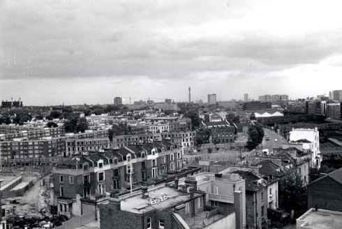
Below is a panoramic view of North Paddington bordered by North Kensington at the top. You can see the Kensal Gas Works and the St Charles’ Hospital tower, formerly the Marylebone Infirmary. [Click on the image to see a bigger view]
The Great Western Railway to the left cuts unimpeded through the built-up area.

This is the same view a a short time later. The second tower block – Oversley House – is under construction.

Below,a closer view. In the background you can see Ladbroke Grove bridge more clearly, connecting North Kensington to Paddington. If you look closely there is also a footbridge on the left that appears to have a tree growing out of it. Obviously it isn’t, but from this angle the bridge resembles a horizontal chute. It wasn’t a very appealing crossing, but it was a shortcut through to Westbourne Park and North Kensington. I made use of it many times, sometimes late at night, probably not a very wise thing to do with hindsight, but it saved time. The dilapidated Victorian houses, a stark contrast to their taunting new neighbours, await the bulldozer. Nowhere was there a more densely packed neighbourhood than in this part of Paddington.

The houses come down and a temporary wasteland is created, with the exception of these houses in the foreground. They do seem a little grander than the terraces behind them and I wonder why they are still standing at this point when their neighbours have been demolished

The strange case of the solitary houses. I suspect they were slightly more upmarket than the usual fare in the area. There is also the interesting feature of the residents coming and going as has always been their routine perhaps; shopping or simply getting from one place to another. The lady (left of the house) probably had no idea she was being included in a photographic survey.

If you like trains, then the Great Western Railway before you would have been a spotter’s delight. Below is possibly Alfred Road or Torquay Street in the pre-redevelopment period. There is a builder, or certainly a very brave man,who appears to be intently prodding the side of a roof with a stick. By contrast an elderly gentleman with a walking stick is passing by, perhaps studying the changes in his area. Although there is a lot of pixilation when studying photographs at close range, when they are enlarged there is still enough to intrigue us.

The juxtaposition of the concrete towers to the dilapidated, slum terraces is a striking image – like two Lego blocks strategically placed inside of a crowded moat. Although you cannot see it, running parallel to the two tower blocks is the Grand Union Canal.

Below is a composite image of three photos showing the lower end of the Harrow Road. None of the shops seen here along the length of the long street now exist. Many have been replaced by the various convenience stores and take-away outlets you see today. On the corner of Bourne Terrace the Stowe Club was opened, now a doctor’s surgery and offices I believe. Many residents within Paddington and North Kensington did a lot of their shopping along the Harrow Road.
Westbourne Grove, by contrast (to digress a little), was more the Bond Street of the area with William Whiteley identifying the road as having future potential once the underground railway opened in 1863 and many more transport routes being opened up. He opened a small drapery in the area, tentatively doing what is essentially market research and gaining experience before expanding to what later became the department store, Whiteley’s of Queensway, attracting and catering for the wealthier clientele residing around Bayswater and Hyde Park.

Here is another image of the same area, magnified a little to give us more detail. If you look closely you will see the ‘Tardis’, a police box, no doubt placed there to keep an eye on things whilst the area was undergoing its concrete revolution. A billboard to the left advertising glue is almost comical given the toy-like remodelling we see from this perspective

In the picture below, the Post Office Tower, the highest building in London at the time, can be seen in the distance. It is almost impossible at this point to imagine the Westway being a part of this landscape. The Harrow Road here is clearly seen under an open sky. Within a few short years all of the buildings on either side of the Harrow Road in this image were demolished, and the Harrow Road itself partially covered by the huge motorway above it. Engineering ingenuity in the name of progress or engineering folly – a question that is still debated today.
Another composite image I pieced together looking north:

I had to include this one as it’s my old address – Gaydon House. I lived there for about 26 years. That is a long time to be anywhere. The rather forlorn, gothic-looking tree in the foreground appears in quite a few of the photographs before it was unceremoniously cut down to make way for more flats and other younger saplings ready for the next generation. All remnants of what came before, almost vanished within a ten year span.

Below is Westbourne Park Villas. It runs parallel to the Great Western railway on the other side of the tracks. The spire of St Matthew’s Church can just be seen to the right of the image and in the middle you can just about make out the dome of Whiteley’s. A little behind that is the dome of the Royal Albert Hall. On the left, along Bishops Bridge Road, are a series of buildings that make up what was known as The Colonnades up until recently, before Waitrose took over. Further back, (I had to really expand this image), you can make out the four chimneys of Battersea Power Station. After being derelict for many years, and a few investors later, it is now undergoing a major redevelopment: the usual combination of luxury flats and shopping outlets so typical of London now.

Here’s another view of Westbourne Park on the other side of the tracks, looking further west towards Notting Hill and Kensington – an interesting mixture of modern flats and late 19th century villas.

And finally, a colour image of the Harrow Road most likely photographed by Selwyn from Wilmcote House, the first tower block to be built of the six now in existence. Two buses (probably the number 18) can be seen making their way north. Interestingly there existed along the Harrow Road a 2 ½ mile track from Amberley Road to Harlesden around 1888 for trams. These were replaced around 1936 by trolleybuses and later still (1961-2) by motorbuses such as the ones you see in this image.

As always Selwyn’s wonderful collection of photographs fails to disappoint. Dave and I have posted a number of them now on the blog knowing that you will probably appreciate them as much as we do. Or at least we hope you do. The posts I have written thus far about this part of Paddington are obviously a trip into a past that pre-dates my tenancy there, but in my view, still feels so very familiar and nostalgic. Now, not having lived in the area for a few years, I feel more like an outsider looking in with an abstract knowledge of a community I was once a part of. What I realise when I look at historical photographs, is just how temporary everything is, and how changeable. The only forever in these instances are images such as these frozen in time. Perhaps this is why we always find them so appealing. A record of a slither of time that we witness much as a fictional Time Lord in a Tardis would. Except we do it without having to travel very far.
Postscript
Thanks to Isabel for another fascinating post. I particularly like the panoramas she has created, something Selwyn himself used to do using the medium of sellotape. Once again, if anyone knows an easy way of adding an author in WordPress I’d be grateful.
I will spend my week off working on some new posts in an unhurried languid sort of way and return next week with some of the usual stuff.
Dave.

