When I first looked at Bernard Selwwyn’s pictures of 1950s Paddington I had no idea I was working with someone who knew a great deal more about the area than me. So this week my colleague and friend Isabel Hernandez is guest blogging, about a neighbourhood she knows very well:
You may recall a post Dave wrote a little while back called Unfamiliar Streets: Paddington 1959…It so happens that when I had the opportunity to view the photographs within that blog I realised to my surprise that I was very familiar with these northern Paddington streets. Views of the Warwick Estate prior to its redevelopment beginning around 1959 and the early 1960s were images I had never seen before, and considering I spent my entire youth growing-up on the relatively new estate, it really was like entering a time capsule. Very few of the original buildings survive now, with the exception of St Mary Magdalene’s and the local Victorian schools which I will talk about later, and some of the bigger, grander houses around Blomfield Villas. There have been name changes too: some abolished, others given to rebuilt roads such as Clarenden, Woodchester and Brindley.
Below is an image of Bourne Terrace, previously Westbourne Terrace North. The photograph appears to have been taken from Torquay Street which backs on to the now Westbourne Green Sports complex, opened around 1976. The railway lies directly behind that with the Westway looming large alongside it. On the corner of Bourne Terrace you can see 264 Saws Ltd and various blocks which no longer exist. They look to be derelict and ready for demolition with people going about their daily lives as usual. Nobody in that scene seems to have noticed the camera.

Here’s another photograph showing Bourne Terrace, only this time one of the blocks has already been demolished. Already a new build has been erected on the left – the familiar flats of the current Warwick Estate. The spire of St Mary Magdalene’s is clearly visible in the background.

Below is the Harrow Road with Bourne Terrace to the right and what appear to be lines set up for trolley buses. They were certainly gone by the time I moved in. The 18 and 36 bus routes were diesel run, ironically less clean than the electric bus option. All these blocks are now gone: the billboards, the shops. My memories of this part of the Harrow Road are not dissimilar to what exists today. To the right is a high rise block, possibly Brinklow House. Further up on the left, past the block of flats, existed the Westminster Council Offices (now an academy) and below that, garages where I housed my first car. To the right there was a Londis, a video shop (the epitome of visual technology at the time) and George’s chip shop. Each business had a residing family that we all knew well. People tended to stick around in the same community for a long time.

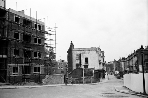
Here’s another street which runs parallel to Bourne Terrace. This is Cirencester Street. To the right is the Roman Catholic chapel, Our Lady of Sorrows where I first had confession and had to wrack my 8 year old brain into confessing something inoffensive, like I really didn’t like my breakfast that morning, much to the priest’s amusement. Soon after, I did my First Holy Communion where my friends and I looked rather charming in our white dresses and suits. The chapel itself is quite beautiful inside.
Next to the chapel and above it – although not obvious – is my old primary school Our Lady of Dolours. The school was founded on this site in 1872 having previously been managed by priests of the church of St Mary of the Angels. It’s one of the few schools in London to still have a roof playground. At this point the school had yet to convert the front part opposite its façade into the front playground. I have many fond memories of the old place and I’ll never forget how small it looked when I returned many years later to visit. It must be true for all those who visit their old primary schools. We grow and mature and yet we’re not really sure when and how it all happened.

Here’s the chapel again with the camera facing Desborough Street. The blocks to the right face onto the Harrow Road looking rather shabby and derelict.

Below is a view of Our Lady of Dolours from a higher vantage point. Already the shabby, block opposite has gone and new flats are being built in the surrounding area. The high-rise block under construction is Wilmcote House, the first of six, high- rise blocks in the Warwick and Brindley Estates.

Here’s another high vantage point of view. Our Lady of Dolours and Our Lady of Sorrows sectioned off and Wilmcote House nearing its 20/21 storeys. I lived in Gaydon House, nearest to Royal Oak and possibly the last of the six blocks to be built. Great views over London if you lived on the uppermost floors.

Here’s Wilmcote House from the view point of St Mary Magdalene’s. To the far left is Edward Wilson C.E School. I assume named after the physician and naturalist who died on the ill-fated British Antarctic expedition lead by Captain Robert Scott in 1912. Edward Wilson practiced as a doctor in Paddington in his earlier years.

Edward Wilson School seen from the back possibly from Cirencester Street. The skyline is a little different now with Gaydon House directly opposite the front of the school and the Westway marking a path through the lower horizon towards Edgware Road and Marylebone Road.

St Mary Magdalene’s in the distance with the endless row of houses leading up to it. This gives you an idea as to how little space there was. It was designed by the architect George Edmund Street and it is often described as a ‘long, tall narrow design’ simply because the layout of the former streets gave little room for width. Now, of course, there is a spacious green behind the church with the Grand Union Canal running parallel to it. As children after school lunch, usually a hideous concoction of hard boiled potatoes, spam and simpering vegetables that would probably make Jamie Oliver’s toes curl, we would be taken by dinner ladies to the green to play. We would often dare each other to go up to the church wall, put our hand on it and count to ten – seems perfectly harmless – except we just knew it had to be haunted. To our point of view a gothic behemoth such as that, towering over our small frames was good enough reason to allow for our vivid imaginations to concoct some fantastical cowl covered floating monks to be living there in all their frightening silence. I know now that this is quite impossible. St Mary Magdalene’s was only completed around 1878. No cowled monks in the area at the time as far as I know.

Here is the church again a little closer, from the other side of the canal. I have always admired its red brick walls and unassuming character. It’s not surprising it is often used as a film location. A church ‘completed by degrees’ in the middle of a crowded residential area. Now it stands as the centre piece of the Warwick Estate. If you want more details about the church, Pevsner’s London 3: North West is an interesting read.

The Warwick Crescent development underway; note the leaning lamp-post in stark contrast to the massive crane beyond the corrugated barriers. Out with the old in with the new. It seems a shame that these could not have been restored – as far as street furniture goes these were rather attractive.

The new blocks of flats were going up as soon as the rubble from the old houses was cleared. Presumably, rather than demolish everything in one fell swoop and displacing many residents, it made sense to demolish sections and rebuild, that way you could re-house people in increments and not displace them for too long.
Here is a clearer photograph of the flats under construction. These are what you will find on the Warwick Estate now.

I will conclude my post with this image. Here, the old and the new seem to co-exist in an absurd time warp: old houses new flats. Note the lampposts again! Here we see (what I assume) are residents passing through what appears to be Lord Hill’s Road. It now connects Senior Street with Delamare Terrace. I imagine a mother with her shopping trolley; gentlemen in suits, perhaps finishing work for the day; somebody on a motorbike and a chap looking at the camera on the other side of the road taking an interest in what our photographer is doing. It’s difficult to see unless you expand the image. They all seem to be taking the huge redevelopment in their stride quite literally. I wonder what they thought of it all.

Postscript:
I came to the Warwick Estate as a child in the early 1970s and my first impressions are still relatively clear in my memory: tall high-rise blocks, lots of green spaces to play in, a canal full of sticklebacks and the ever stoic St Mary Magdalene’s at the centre of all the residential flats. Being a new girl on the block what I experienced was the London County Council’s post war answer to social housing. I never realised – now looking back at maps and photographs – just how densely populated the area was with narrow streets. A true Victorian relic. I had never seen what the area looked like before my tenure there so to have looked at these images and given the opportunity to talk about them was a real treat. Some of you reading this may be familiar with these Paddington streets and may even remember how it was before the cranes arrived on the scene. There is so much I’m still learning about my old haunt; for example, I had no idea that the painter, Lucien Freud had a studio in Delamare Terrace and later in Clarenden Crescent. Did you? History always has a way of inviting you to delve further. I would never say I know everything there is to know about my old address because I clearly don’t but I hope to have piqued your interest just a little and that you have enjoyed looking at these photographs as much as I have.

